Geographic Information Systems (GIS)
GIS
GIS is a technology that is used to view and analyze data from a geographic perspective. The technology is a piece of an organization's overall information system framework. GIS links location to information (such as people to addresses, buildings to parcels, or streets within a network) and layers that information to give you a better understanding of how it all interrelates.
Geography
Geography isn't just an academic subject, it's a serious discipline with multibillion dollar implications for businesses and governments. Whether it be choosing sites, targeting market segments, planning distribution networks, responding to emergencies, or redrawing country boundaries, all of these problems involve questions of geography.
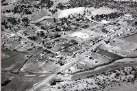
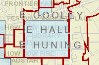
Map Gallery
Disclaimer
By viewing the maps above you agree to the following:
This is a pictorial representation of geographic and demographic information. Reliance upon the accuracy, reliability, and authority of this information is solely your responsibility. The City of Show Low, in Navajo County, Arizona, a political subdivision of the State of Arizona, has complied for its use certain computerized information.
This information is available to assist in identifying general areas of concern only. The computerized information provided should only be relied upon with corroboration of the methods, assumptions, and results by a qualified independent source. The user of this information shall indemnify and hold free the City of Show Low from any and all liabilities, damages, lawsuits, and causes of action that result as a consequence of his reliance on information provided herein.